by Robert Verish
![]()
by Robert Verish
The Panamint Valley "Crater"
There has always been a keen interest in "craters", whether they be formed by explosive volcanic eruptions, or by a heavenly body falling from the sky. But it's my distinct impression that craters are even more popular, now. No doubt, all the press regarding Potentially Hazardous Asteroids has helped fuel this recent interest. Yet, it goes beyond that, because the interest is now broader. The study of craters is now a "cross-disciplined" science. We can thank all the meteoriticists and geologists, from Nininger to Shoemaker, for this new-found respect in the study of craters.
What with the neighboring state of Arizona being home to one of the more famous impact sites, namely Barringer's "Meteor" Crater, there has developed an envy that has driven Californians to find a crater to call their own. So, it comes as no surprise that a great deal of interest was created when, in 1960, Robert S. Dietz recognized a crater while examining aerial photos of the Panamint Valley, which is in the Mojave Desert of southern California. At that time, Dietz was employed at the U.S. Navy Electronics Laboratory in San Diego. By December of that year, he and Edwin C. Buffington had made a three-day reconnaissance survey of this "Panamint Crater". Since there were geologists stationed at China Lake's Naval Ordinance Test Station, and because of its proximity to Panamint Valley, a team from there joined the study and surveyed the crater in January 1961. Whether Dietz was a member of the Meteoritical Society in 1960, I am not sure. But for sure, by June 1961, he was a member when he presented his findings in Nantucket, Massachusetts, at the 24th Meeting of the Meteoritical Society.
This presentation in June 1961 by Robert Dietz was selected to become a paper that was eventually published in the February 1964, Volume 2, Number 2 of Meteoritics. Consequently, this is the only place that the Panamint Valley "Crater" appears in the literature. For the readers convenience, I have shown this short paper in the images BELOW:


The results of the "subsequent study", that Robert Dietz mentioned in his 1964 paper, were never published. Again, for the convenience of researchers, I have made a "reprint" of the last version (circa 1962) of the rough draft by Lee Humiston of this "subsequent study", which follows below:
"Click" the above image to ENLARGE!!
(Large file, please allow time for the image to download)
By
Lee E. Humiston, Sheldon D. Elliot Jr., J. Kenneth
Pringle, and Pierre St. Amand
Michelson Laboratory, U. S. Naval Ordinance Test
Station, China Lake, California
This paper presents results obtained to date from
the study of a topographic feature resembling a meteorite crater, situated in
Panamint Valley, Inyo County, California (Lat. 36°05'N, Long. 117°22'W). In its present form, the crater located in
an alluvial fan, is closely circular in shape, some 225 feet in diameter and 45
feet deep, and lacks a raised rim.
Drilling
and excavation have revealed that originally it was an open pit at least 135
feet deep, and has filled to its present depth chiefly by water
deposition. This indicates a considerable
greater depth-to-diameter ratio [0.9 to 1] than would be expected for a
meteorite crater of this size [6 to 1].
No meteoritic matter has been found, either in the fill material or in
the neighborhood of the crater. The
presence of faulting and exposed limestone beds in the adjacent foothills
suggest that the feature may well be a limestone sink. It seems highly improbable that volcanic
activity can have been responsible for its formation.
Animal
remains found in the crater fill material have been submitted for
identification and radiocarbon dating.
Further exploration, using magnetometric, gravimetric and seismic
methods, as well as further excavation, is intended. Although the possibility of a cosmic origin is not as yet
completely excluded, it is probable that further results will be of interest
primarily to geologists, paleontologists, and climatologists.
INTRODUCTION
The existence of an isolated crater, possibly of
meteoritic origin, in Panamint Valley, Inyo County, California was brought to
our attention late in 1960 by Dr. R. S. Dietz, of the Naval Electronics
Laboratory, San Diego, California, who had observed it in an aerial photograph
of the region. The crater is situated
at Lat. 36°05'N., Long. 117°22'W., in an arid
alluvial fan, approximately one mile from the foot of the Argus Mountains on
the western side of Panamint Valley. An
aerial reconnaissance flight from the Naval Ordinance Test Station provided the
series of photographs presented in Figs. 1 through 5.
"Click" the above image to ENLARGE!!
(Large file, please allow time for the image to download)
DISCUSSION
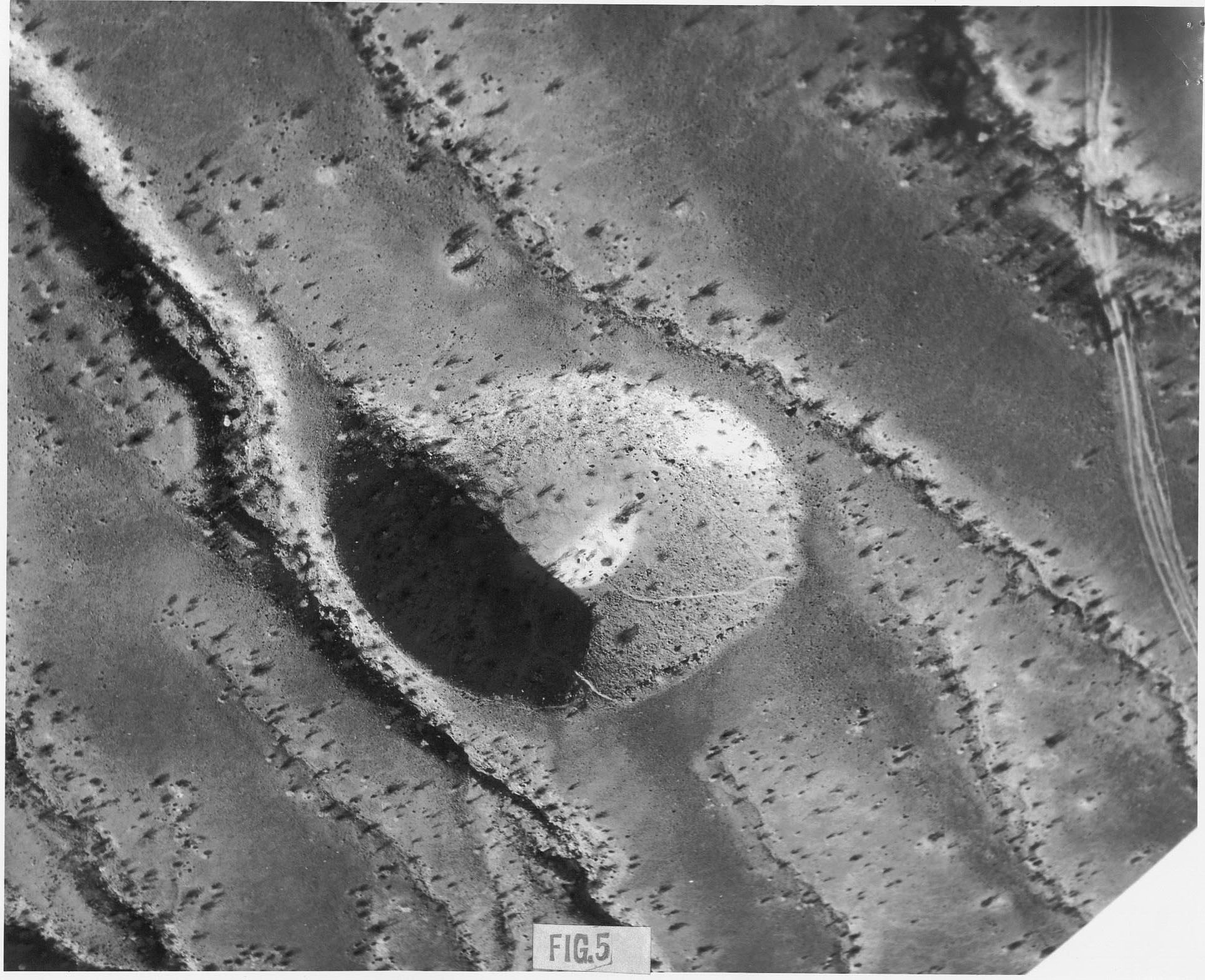
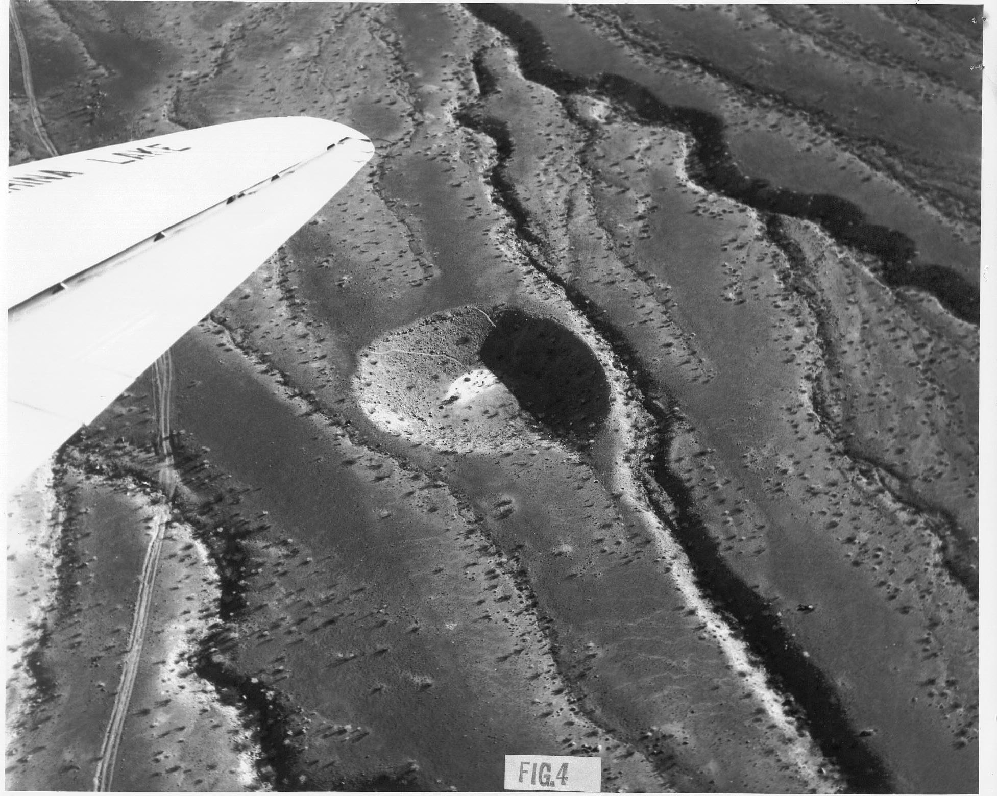
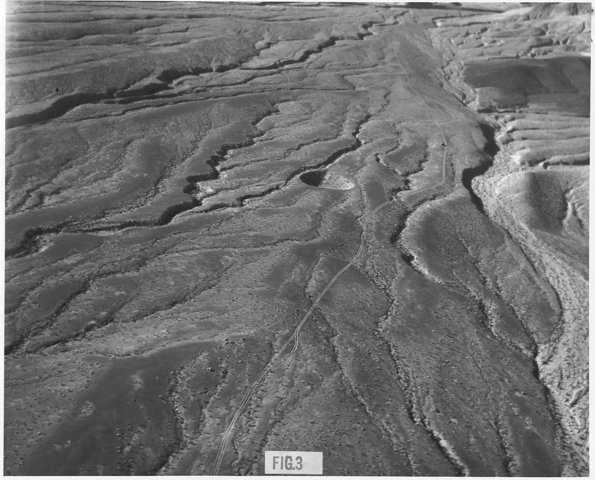
The crater is nearly circular in outline, with
relatively steep walls; the northeastern half of its floor is covered with a
playa. A small gully enters the crater
on the southwest from the uphill slope of the fan. The trails spiraling into the crater have apparently been made by
wild burros in search of water. The
upraised rim usually associated with meteorite impact craters does not appear
in this case, although gullies bypassing the crater on either side look as
though they might have been displaced outward around it.
In January 1961, the site was visited by a party
from the Naval Ordinance Test Station, who surveyed it and searched the crater
and its vicinity for meteoritic material.
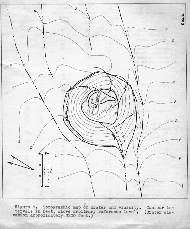
The survey (see map, Fig. 6) showed the crater to be approximately 225
feet in average diameter, and to have a depth of some 45 feet from the highest
point on the rim to the floor. These
dimensions yield a close fit to the empirical log diameter - log depth curve
obtained by Baldwin (1949) for explosion pits and terrestrial meteorite
craters.
The floor is reasonably flat, except for a small fan
at the lower end of the gully, and is about 80 feet in diameter. The playa is of extremely fine
water-deposited silt, while the floor material becomes progressively coarser
towards the gully fan. The slope of the
walls is approximately 30°, and at several points below the rim, ledges of
cemented alluvium are exposed. The rim
was not found to be raised appreciably above, nor depressed below, the original
fan surface, nor is any tilting of the rather coarse alluvial bedding
apparent. The fan is composed of
water-deposited conglomerate, ranging in size from silt to large boulders with
no apparent graded beds.
"Click" the above image to ENLARGE!!
(Large file, please allow time for the image to download)
Aside from the apparent deflection of the
neighboring gullies, which might be regarded as fortuitous, there is no
evidence of any disturbance of the fan in the vicinity of the crater, nor does
any material appear to have been thrown out over the surrounding terrain. The fan surface has the same composition
near the crater as at a distance, and no change in the coloration, degree of
desert varnish, nor in the character of the lag surface (desert pavement) can
be detected, either on the ground or from the air. There is likewise no trace of volcanic activity in or about the
crater, although some lava probably of early Pleistocene age is found about 1
mile west.
The possibility of an artificial origin could at
once be completely discounted. There
were no signs of excavation, and counting of growth rings in sections taken
from shrubs growing on the crater floor showed the feature to antedate by far
any ordinance activity in the area.
The search for meteoritic material was considerably
hampered by the large amount of natural magnetite and garnet present in the
fan, and by the dark desert varnish covering exposed pebbles and rocks. A thorough canvas of the crater and its
vicinity was conducted, both visually and with the aid of a large AlNiCo
magnetic rake, and samples were studied in the laboratory, but no recognizable
meteoritic material was found.
It appeared from this preliminary survey that
further efforts to determine the origin of the feature would be desirable. A truck-mounted auger was lowered into the
crater, and, during the month of February, a series of holes was drilled in a
radial pattern over the floor, with the objective of determining the original
profile of the crater and locating, if possible, any meteoritic mass which
might be present. Drilling was
continued in each hole until material either too coarse or too hard for further
penetration was encountered. Around the
periphery of the floor coarse gravel and rocks limited hole depths to a few
feet; nearer the center the holes reached several tens of feet, the fill
material evidently consisting of more or less a sandy silt with occasional
layers of gravel and a few larger rocks.
It appears that the pattern of playa and gully outflow observed at the
surface must persist to considerable depths.
With a few localized exceptions the material brought up by the drilling
was extremely dry, indicating an efficient subsurface drainage mechanism.
Of the sixty holes thus drilled all of those
penetrating below thirty feet were concentrated in a relatively small area
about twenty feet north of the apparent center of the crater. One of these holes reached the limit of the
available drill string, going to 73 feet without obstruction.
For comparison, an attempt was made to drill several
holes in the fan outside the crater.
The material encountered here proved considerably denser and more
compact than anywhere within the crater; none of the holes penetrated more than
a few feet.
"Click" the above image to ENLARGE!!
(Large file, please allow time for the image to download)
Some fifty samples of material brought up by the
drill, as well as, a dozen or so obtained from the surface in and around the
crater, were taken to the laboratory for detailed study. Standard specimens of the drill cuttings
were weighed out and washed free of silt, and their magnetic fractions were
extracted and examined microscopically (see Table 1). While a small number of magnetic spherules of presumably meteoritic
origin were found, these were no more abundant than in typical surface samples
from other locations. No other
recognizably meteoritic particles were found, and none of the questionable
fragments tested yielded any indication of the presence of nickel. Similar results were obtained with the
surface samples studied.
As for the next stage of the investigation, a
contract was let for a five-by-six foot timbered shaft to be sunk to depth of
100 feet below the crater floor, in the vicinity of the deepest drill
holes. Down to approximately 87 feet
the fill was found to consist of fine-grained, well-bedded layers of
water-deposited silt, sand, and fine-pebble gravel, essentially similar to the
material at the surface. Locally,
larger boulders were encountered which presumably had tumbled in from the
crater wall. It would appear,
therefore, that the crater had at one time the form of an open pit some 135
feet deep, and rather less than its present 225 feet in diameter, a conclusion
reinforced by the large numbers of bones of small, medium-sized, and relatively
large animals encountered with increasing frequency as the excavation
progressed. If the deposition of this
portion of the fill material can be assumed to have proceeded at a rate
comparable to that prevailing in the recent times, which the appearance of the
strata traversed by the excavation would suggest to be the case, the filling of
the crater to its present depth must have occupied a considerable span of time,
probably several thousand years. Samples of the animal remains found have been submitted to experts
for identification and radiocarbon dating, with the objective of establishing
an absolute time sequence.

"Click" the above image to ENLARGE!!
(Large file, please allow time for the image to download)
At 87 feet there is a well-defined transition to a
completely chaotic zone of extremely loosely-packed boulders, cobbles,
pebble-sized gravel, sand, and silt with numerous voids, which continues to the
bottom of the shaft. This material is
quite different in appearance from that in the undisturbed parts of the fan,
although the same type of rocks re represented; it would appear to have tumbled
into place in an earlier, more cataclysmic phase of the filling process. Like the stratified layers above, the
material in this zone was found to be completely dry. Examination of samples from these lower depths for meteorite
fragments, again yielded negative results.
(see Table 1.)
A magnetic survey of an area approximately 1500 feet
square, centered on the crater, was conducted with the aid of a Varian M-49
proton precession magnetometer. This
survey was complicated considerably by topographic effects, by local anomalies
of as much as a few hundreds of gammas, due evidently to boulders, both buried
and exposed, of material differing significantly in magnetic susceptibility
from the general run of the alluvium in the fan, and by the presence of iron
stakes and cables associated with the excavations. In general, however, the picture is one of an increase in the
magnetic intensity at a rate of, roughly, 100 gammas per 1000 feet downslope
along the fan, upon which is superimposed an anomaly amounting to a few tens of
gammas, negative to the south and positive to the north (magnetic) of the
crater. It appears, from comparison
with data obtained in traversing nearby washes and gullies, that this anomaly
may well be purely topographic, the crater thus representing a void in the
moderately magnetic alluvium, while at the same time the alluvium increases in
depth over a basement of lower magnetic intensity for the region (ca. 51,500
gammas) is very close to the value projected for 1961 from the magnetic charts
of the U.S> Coast and Geodetic Survey.
No satisfactory values could be obtained within the shaft, due to the
presence of ferrous materials in the timbering.
"Click" the above image to ENLARGE!!
(Large file, please allow time for the image to download)
A geological reconnaissance of the crater, the fan,
and the neighboring mountains yielded evidence suggesting that the crater may
lie over a fault in a limestone basement, lying at no great depth below the fan
surface. This opens the possibility
that the crater may have originated as a limestone sink [sinkhole]. Some one-half million cubic feet of
[alluvial] material is missing from the crater in its present form, while if
its original depth was on the order of 135 feet, and the water-deposited portion
of the fill has come from elsewhere, at least twice this volume must be
accounted for. In the absence of a
raised rim, or of evidence that the missing material was distributed over the
surrounding terrain, removal from below offers a reasonable solution to this
problem.
There remains the possibility that this relatively
deep crater was caused by a penetrative, rather than explosive, impact of a
meteoritic body of large mass and high density, moving at a relatively low
velocity. In this event, the missing
material would have to be accounted for by compaction of the relatively porous
alluvium, which might be taken to explain the apparent deflection of the
adjacent gullies. To have avoided
detection thus far, the impacting body, if intact, must either be of abnormally
low magnetic susceptibility, or else be buried to a considerable depth. If it is presumed to have disintegrated upon
impact, it must have been composed of materials not readily distinguishable
from those comprising the alluvium already present.
Plans are underway to conduct additional magnetic,
gravimetric, and seismic studies of the crater and its vicinity. It is also hoped that the present
excavations can be extended, both downward through the chaotic portion of the
fill, and horizontally along the discontinuity between this and the material
lying above. Apart from the fundamental
problem of its origin, the crater’s subsequent history appears to offer
considerable opportunity to geologists, climatologists, and paleontologists for
future studies.
We would like to express our appreciation to Drs. R.
E. von Huene, W. R. Haseltine, and R. L. Engel for their invaluable assistance
in these studies, and to Mr. J. L. Eisel for his aid in taking various
measurements.
REFERENCES:
Baldwin, R. B.,
(1949), The Face of the Moon, Univ. of Chicago, p.132.
APPENDIX:
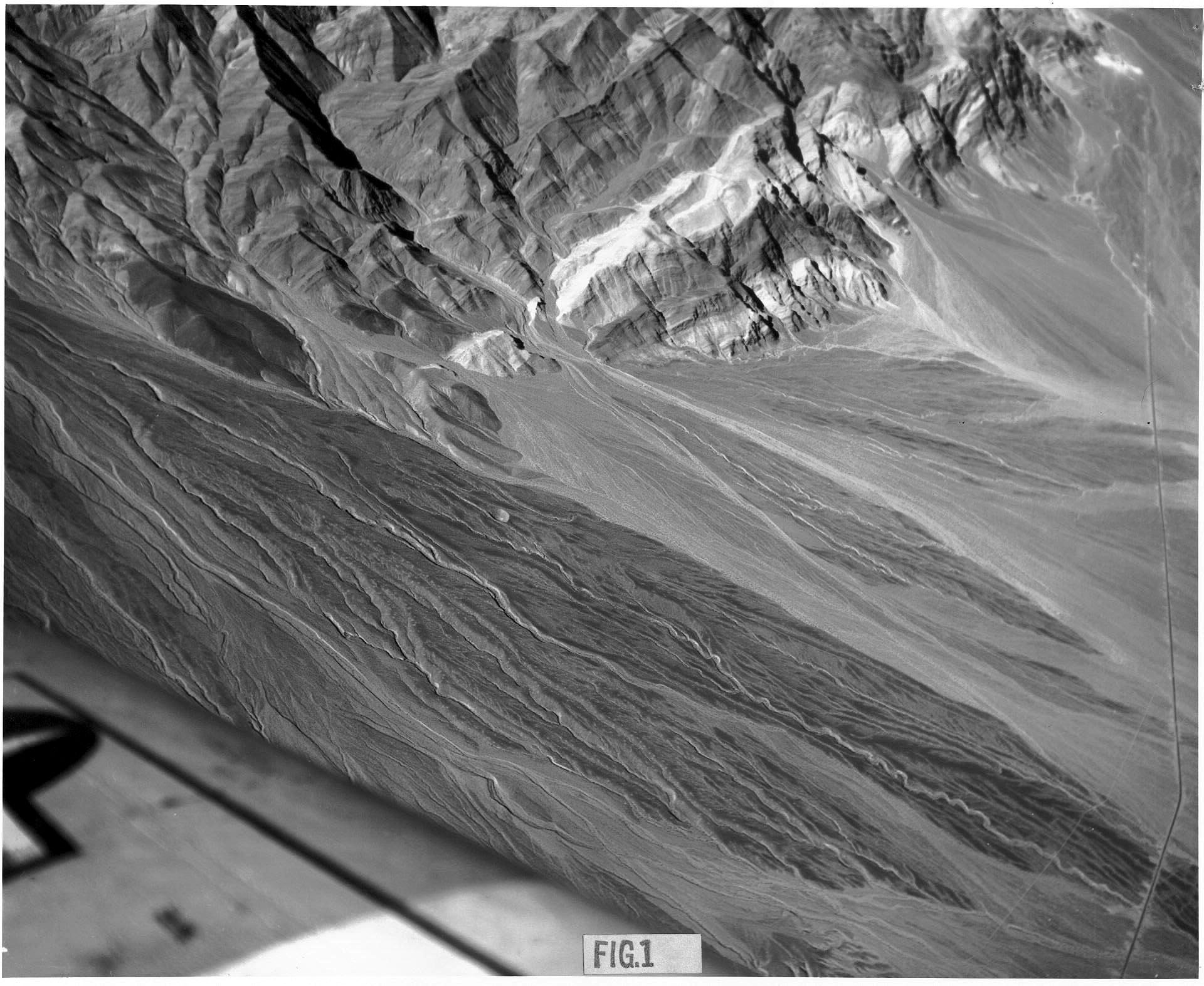
FIGURE 1. - Aerial Photo of Crater and Vicinity
FIGURE 2. - Aerial Photo of Crater and Vicinity
FIGURE 3. - Aerial Photo of Crater and Vicinity
FIGURE 4. - Aerial Photo of Crater and Vicinity
FIGURE 5. - Aerial Photo of Crater and Vicinity
FIGURE 6. - Topographic Map of Crater and Vicinity
TABLE 1. - Magnetic Separation Data
TABLE 1. - Magnetic Separation Data (Cont'd.)
As I mentioned earlier, the results of this study have never been published. The "first author" of the above paper, Lee Humiston, attempted to have it published. He submitted a rough draft to the editor of Meteoritics, the journal of the Meteoritical Society at that time. But the editor, Dorrit Hoffleit, declined his offer, and in a letter to Lee Humiston, dated 2 October 1962, suggested that the paper "belongs in a California geological publication". (But she did accept for publication his other paper, entitled "The Ridgecrest Meteorite, in which he was the finder, as well as the author.)
To see a scanned image of this letter, "Click"...
HERE! - Letter from the editor of Meteoritics
The topic of the next pseudo-crater article will be about the controversial "Elko Crater Field".
For for more information, please contact me by email: Bolide*chaser
![]()