by Robert Verish
![]()
by Robert Verish
Willcox Playa 004 - Image Gallery
The subject of this month's "Bob's Findings" article is on the Willcox Playa 004 chondrite, a meteorite that I found during a "side-trip" while attending the February 2004 Tucson Show - 1 year ago. Although this is a small, weathered Ordinary Chondrite, it is the find location, a large dry lake in southeast Arizona, which has garnered the attention of some of the meteorite collectors who attend the Tucson Show, and I felt that it would make an appropriate topic for this month's article. The following is actually an "Image Gallery" of that locality, and is mostly images of the meteorite "as it was found" on the playa and while under study in my lab.
UPDATE to this article - this meteorite is now CLASSIFIED:
L6, S4, W2 (Fa 24.5+/-0.3%, Fs 20.6%, Wo 1.2%)
A "group meteorite hunt" to Willcox Playa was much discussed by the meteorite collectors attending the 2004 Tucson Show, but after receiving unfavorable reports from the field about the conditions in the Willcox area (due to recent storms), the planned group outing was called-off. In particular, a detailed account was posted to the Meteorite-List by Rob Matson about how his efforts to gain access to the Playa were repeatedly turned-back by road conditions that were either too muddy or gullies that were too deeply eroded.
But, come the morning of the planned group-outing, the skies were clear and sunny. And since I had promised my wife, Beth, that "we would get in some sight-seeing while in SE Arizona", I decided that we would drive out to Willcox and check out the "dry" lake just to see how much water there was. After all, I had been planning all year long to make this Tucson Show side-trip to Willcox Playa, long before the "group-outing" was ever mentioned, and even if the Playa was submerged, just seeing which direction the waves were breaking would have satisfied my "urge".
And besides, on my first visit to this Playa, back in February 2000, there was water on the "dry lake" even then, yet I still made a find (Willcox Playa 002) close to the shore. (To read more about Willcox Playa and to see images of Willcox Playa 002, "Click" here on "Field Notes" for a link to my February 2004 - Bob's Findings article.) That's right. This "side-trip" was to be a revisit of a former find location. And with a little luck, I might be able to access that former find location.
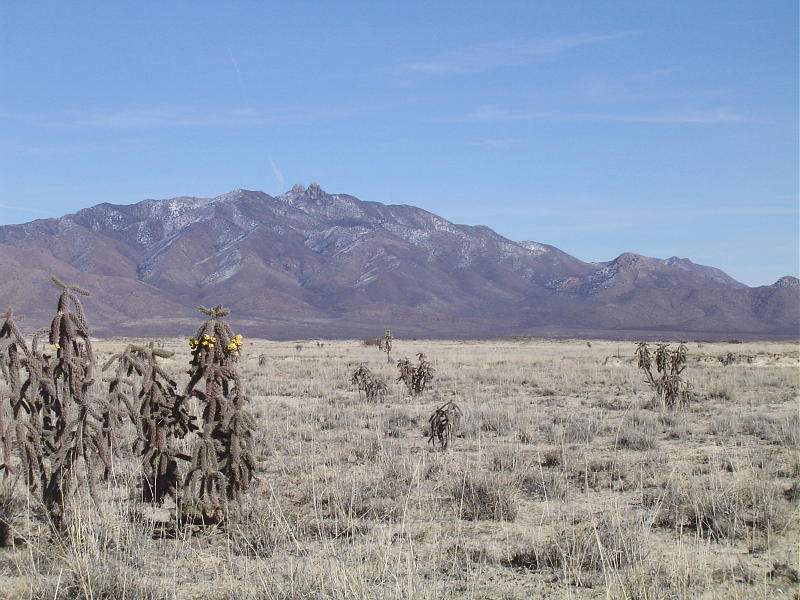
After driving more than an hour east of Tucson on Interstate 10, I could finally look out over Sulphur Springs Valley and see the outline of Willcox Playa. And from that vantage point, it looked as though the middle of the lake was dry, that only the margin of this playa appeared to be wet!
My plan of attack was to check out the south end of the lake and hope that there would be a "dry" access to the Playa.
Although the recent storms had brought a dusting of snow on the Dos Cabezas Mountains, and had brought out blossoms on some of the cacti that border the Playa, the ground that winter was still quite dry, as was evident by the lack of green plants in this mostly brown chaparral. -
Below is an image of the yellow fruit on one of the cactus (Whipple Cholla) that was in bloom the previous year -

My initial attempts to access the "dry" lake were frustrated by encounters with shorelines that were too muddy. (The first rule in the Code of Dry Lake Meteorite-Recovery is to never drive on a lakebed when conditions are so wet as to have the mud stick to the tires of your vehicle. We have great disdain for those who leave deep ruts in a lakebed.) But an access was finally found the afforded some ability to drive around the wet spots. As I worked my way out onto the lakebed there were several instances when I thought for sure my entry was going to be blocked, but luckily there was always an isthmus of just -dry-enough surface wide enough to allow the truck to pass on through. It is a feeling that is very hard to describe when traveling on a dry lake. When you travel for miles and the only tire tracks you encounter are your own. It tends to build confidence. It didn't bother me that the ground was littered with corroded bullets and rusted debris, I just knew that it was only a matter of time (and distance traveled) until one of those pieces of shrapnel would actually be a meteorite.
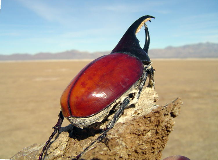
Something else that easily caught my eye on the dry lakebed surface was this carcass of a male Rhinoceros Beetle (Dynastes granti) the largest U.S. beetle. When alive, this beetle was a grey-green color, but after meeting its fate by getting caught in the wet mud, its carcass has since become desicated and changed color -

We hadn't traveled very far on the lakebed when we encountered a long row of "Caution" signs. Although these signs were very old, and many were in very poor condition, some signs were still readable and were clearly marked with "Warning - Military Test Range - Dummy Ordinance Area". I had no intention to turn back and risk navigating around the mud puddles that I had just spent the last hour struggling through, so I made a bee-line to the north and to the only other exit off of the lake that I knew of - a gated road that I discovered on my previous trip.
The farther from the shore I traveled the drier the lakebed became. The only ordinance that I encountered were HUNDREDS of spent "50 caliber" bullets and an occasional piece of shrapnel. The only "Dummy" on the lake was the one driving the truck. -
While driving to the north end of the dry lake to look for an exit from the dry lake, I spotted a small rust-colored object that seemed to be different from all the other numerous chunks of rusting iron. This one seemed to me to look more like a stone. The image below is exactly how this piece of "stony shrapnel" looked from the window of my truck -
A RUSTY STONE? This one got me to stop the truck and I got out to make a closer examination.
Since I like to identify and image my newly found meteorites BEFORE picking them up, it requires me to get on my hands and knees in order to get a good look through a magnifying glass. The magnet is only used to confirm that the object is NOT a piece of iron shrapnal. It is only used when visual examination isn't conclusive. But in this case, close examination reveals a barred chondrule exposed on a weathered surface of this find that was imaged before it was picked-up -
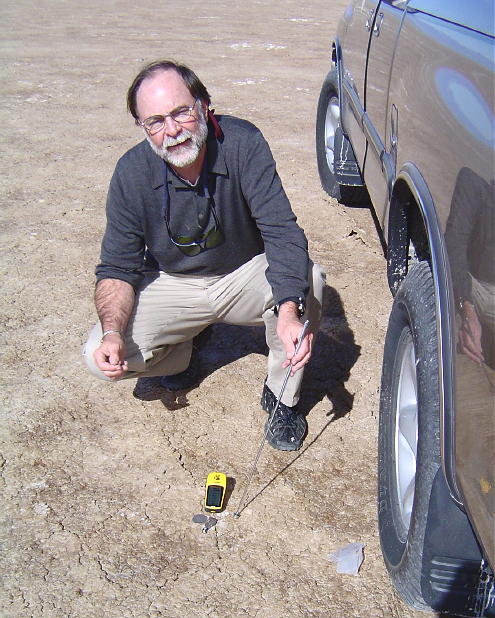
The shot below is where I take a few steps back and shot towards the horizon, trying to capture the GPS unit in the foreground, and in the middle-ground I try to show as much of the immediate area as is possible. I usually take the "1st shot" of my meteorite finds from a point of view that tries to capture the angle from which I first saw the meteorite that I have just found -
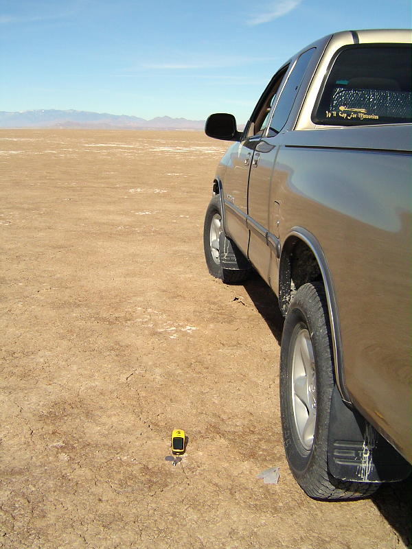
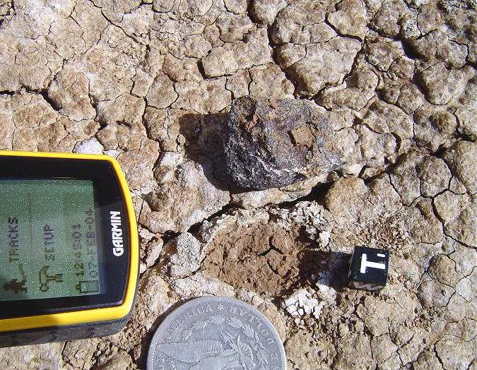
This next shot was taken very close up and from a very low angle point of view that tries to capture the side of the meteorite in the foreground and includes the horizon in the background. The Apache Power Generation Plant near Cochise is in the distant background -
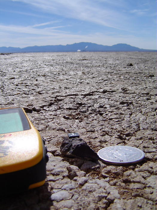
My next shot is like the previous shot, but this time the GPS displays the date and time of the find's GPS waypoint. Since this is very important information, the angle of this shot should clearly be able to read the face of the GPS unit -
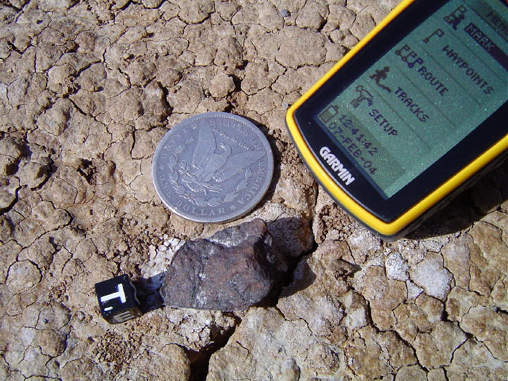
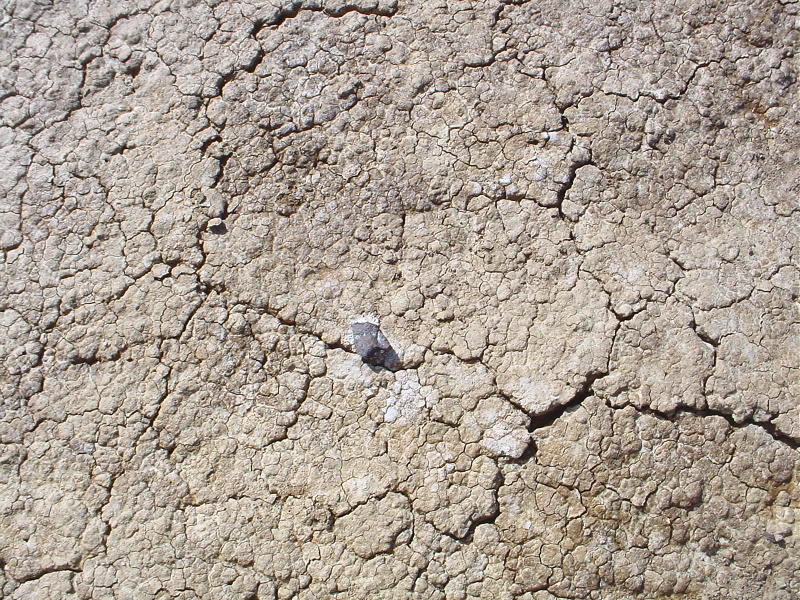
The condition of the soil directly beneath the find is of great interest to those of us recording how meteorites weather, so close-up shots are usually taken for this purpose. One look at this soil and is it any wonder why this meteorite appears to be so weathered? -
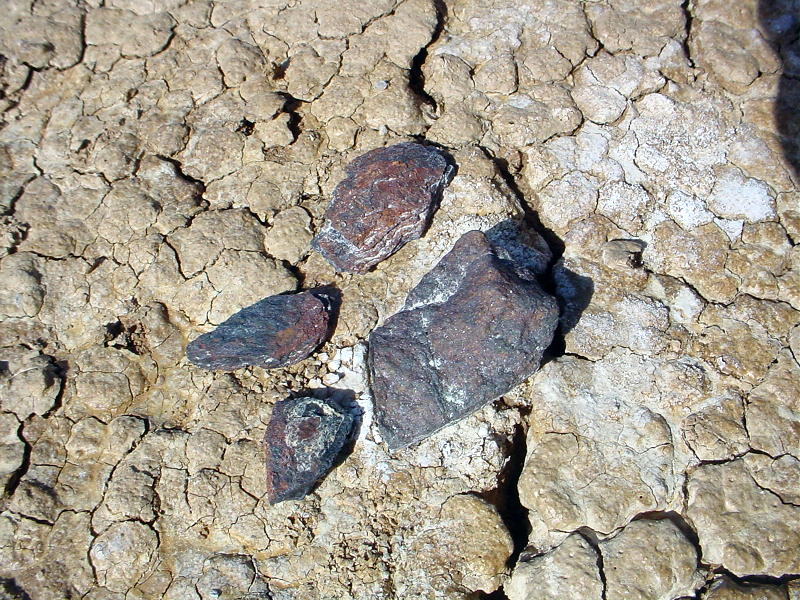
The image below is a comparison of the meteorite "in-situ" along side some pieces of oxidized iron shrapnel. (Forgive me, I almost forgot; the meteorite is on the right - the larger fragment.) While I was taking the above images, Beth looked for more meteorites, and in that short time she found these three fragments of shrapnel. Is it any wonder that she still calls my find "that little piece of Willcox shrapnel"? -
In the next shot my camera is aimed back down to the ground and an overhead close-up image is taken of the meteorite find after it has been just plucked and turned over, now showing its underside and the vacated hole from which the stony has just been extracted -
With the recording and image taking of the find finally completed, I resumed our egress from the playa. Finding the exact exit point wouldn't be easy because all of the dunes and hummocks look alike. I had done this only once before, several years earlier, but I did remember a landmark - an old windmill.
Yet, the closer to the north shore we got, the softer the clay became. If I had tried to drive this surface just one day earlier, it would have been too damp. Luckily I drove up on some older tire tracks and I steered my truck onto these tracks. This reduced the drag of the soft clay on my tires enough that we just made it to sand dunes on the north shore. Another added benefit of following these tracks was that they were made from someone driving onto the lake from the very exit that I was looking for (I have since found out that this is the only driveable exit from the north end of the playa).
But, just as we thought that we had succeeded in exiting the playa and the paved road finally came into view, we encountered a deep, water-filled gully. What really concerned me was that I could see a fresh set of tracks on the other side of the gully, and that driver had decided NOT to cross this stream bed and had TURNED BACK. Faced with having to spend the remaining daylight hours backtracking the entire length of the dry lake, I did some serious thinking.
I figured that it was good news that there were fresh tracks on the other side of the gully, which meant that it would be clear sailing to the paved road - ONCE we could get to the other side! And, even if the truck got stuck in the gully, it was easy walking distance to the paved road and civilization. My decision was to gather as much wood and plants as was possible, and along with shovel-fulls of dirt, to dump it all in the gully, enough to bridge to the other side.
Well, my plan worked.
And a few hours later, I made it to Michael Blood's 2004 Auction. There, I met Rob Matson and from him learned that those sets of tracks on the "other side of the gully" were HIS TRUCK from earlier that week! As mentioned earlier, he had attempted to access the playa but was there much too soon after the recent rainfall. What a difference just a few days would make.
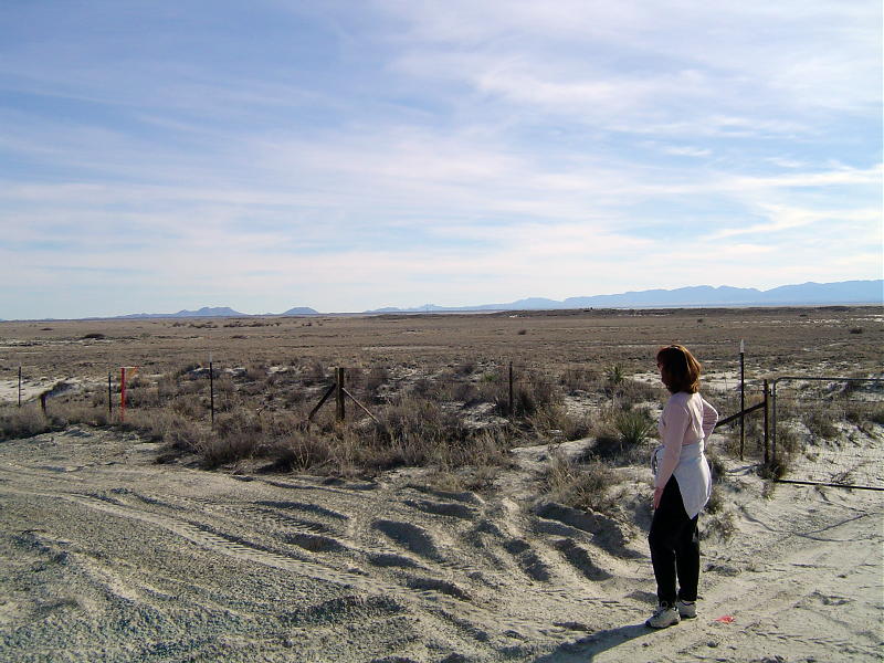
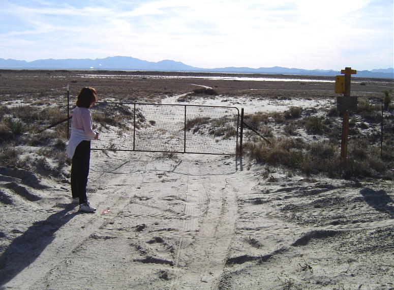
A view of the prairie at the north end of Willcox Playa -
A small pan of the camera to the right, and the gate where the dirt road meets the paved road comes into view. Don't forget to close the gate when you leave -
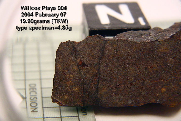
The meteorite depicted in this article is now known as Willcox Playa 004. The recovery was witnessed by Beth Verish.
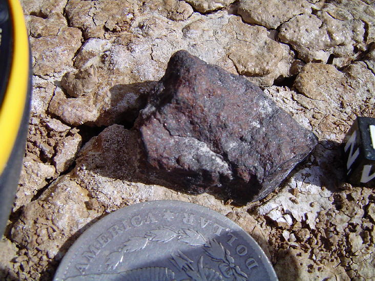
Willcox Playa 004 from Cochise County, Arizona. This image is of the "bottom" side - the side that was on the ground. Some silt from the lakebed surface still clings to the underside of this meteorite.
Willcox Playa 004 from Cochise County, Arizona, is a weathered Ordinary Chondrite (OC) This image is a side view.
Willcox Playa 004 from Cochise County, Arizona. This image is a view of the "south" side.
Willcox Playa 004 from Cochise County, Arizona. This image is a view of the opposite side and it depicts small patches of relict fusion crust.
The meteorite depicted in this article is now known as Willcox Playa 004 from Cochise County, Arizona. This is a close-up image of the "bottom" side. Usually I'll take an image of the "bottom" side just before I make my first cut. Once cut, the stone will lose its "as found" appearance. Most of the dust and lakebed silt will be washed away during the cutting process by the diamond blade coolant fluid. Once cut the specimen needs to be cleaned, anyway, in order to protect the freshly cut surface from contaminants and the corrosive compounds in the alkaline silt. With a little luck, only one cut will be necessary to obtain an adequate "20% type Specimen".
Willcox Playa 004 from Cochise County, Arizona, is an equilibrated OC. Meaning, that the groundmass has melted and then recrystalized, and in the process has obscurred the border with the chondrules. This image is a side view.
In time, a photomicrograph image will be taken, and it can go here, of a Close-up of a cut surface on this Arizona meteorite.
Hopefully, more than one image can go here of a Close-up of a weathered surface of this Arizona meteorite.
Eventually, an image can go here of a Photomicrograph of a thin section of this meteorite.
The topic of my next article will continue the discussion about Willcox Playa Meteorites.
My previous articles can be found *HERE*
Funding for the maintenance of the "Bob's Findings" website is supported by:
Bob's Meteorites and the Meteorite-Recovery Lab.
![]()